|
|
Battle of Leyte 1944, by Biliran on Mar 7, 2016 22:12:00 GMT 8, 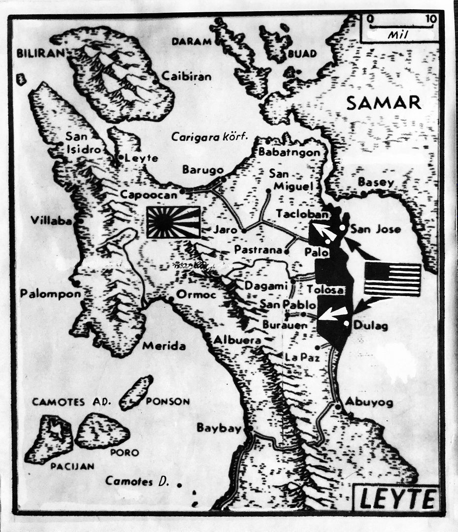
17th October, 1944 was the date of the WW2 landing in Leyte Province by American forces to free the Philippines from Japanese control. The landing area was along the east coasts of Leyte Island around the towns of Dulag, Tolosa, Palo, San Jose and Tacloban, pushing the Japan forces back to the north west.
As you can see from this Press Map released at the time, Biliran Island is also shown in the top left corner.
17th October, 1944 was the date of the WW2 landing in Leyte Province by American forces to free the Philippines from Japanese control. The landing area was along the east coasts of Leyte Island around the towns of Dulag, Tolosa, Palo, San Jose and Tacloban, pushing the Japan forces back to the north west. As you can see from this Press Map released at the time, Biliran Island is also shown in the top left corner. |
|
|
|
Battle of Leyte 1944, by Biliran on Mar 19, 2016 22:34:41 GMT 8, 
1967 American Comic, War-Stories, COMBAT, The Battle for Leyte Gulf, Victory or Defeat hangs in the balance!

1967 American Comic, War-Stories, COMBAT, The Battle for Leyte Gulf, Victory or Defeat hangs in the balance! |
|
|
|
|
|
Battle of Leyte 1944, by Biliran on Mar 26, 2016 21:28:22 GMT 8, 
Very interesting WW2 map produced by US forces of Naval town on the west coast of Biliran Island.
Clearly showing Naval Town and Atipolo to the north and the Sto. Nino area to the south and the Caraycaray River.
Very interesting WW2 map produced by US forces of Naval town on the west coast of Biliran Island. Clearly showing Naval Town and Atipolo to the north and the Sto. Nino area to the south and the Caraycaray River. |
|
|
|
Battle of Leyte 1944, by Biliran on Mar 26, 2016 21:40:46 GMT 8, 
An old WW2 map produced by American Forced showing the area south of Naval Town such as Sto. Nino and the mangrove area of the Caraycaray River.
An old WW2 map produced by American Forced showing the area south of Naval Town such as Sto. Nino and the mangrove area of the Caraycaray River. |
|
|
|
Battle of Leyte 1944, by Biliran on Mar 26, 2016 22:32:58 GMT 8, 
WW2 Map showing Naval Town on Biliran island and the Biliran Strait with Villalon across the water in Calubian Municipality in Leyte Province.
WW2 Map showing Naval Town on Biliran island and the Biliran Strait with Villalon across the water in Calubian Municipality in Leyte Province. |
|
|
|
Battle of Leyte 1944, by Biliran on Mar 26, 2016 22:37:39 GMT 8, 
A very interesting old map produced by American Forces during WW2, showing Biliran Town, Leyte Island and Calubian Town. Notice this is before the Biliran Bridge, so at this time Biliran Island had no road link to the mainland in Leyte Province.
A very interesting old map produced by American Forces during WW2, showing Biliran Town, Leyte Island and Calubian Town. Notice this is before the Biliran Bridge, so at this time Biliran Island had no road link to the mainland in Leyte Province. |
|
|
|
Battle of Leyte 1944, by Biliran on Mar 26, 2016 22:44:43 GMT 8, 
A close up of the WW2 map showing Biliran Town and the Biliran Strait before the Biliran Bridge was built between the mainland in Leyte Island and the Poro Island, so at this time a ferry boat service would have run between Biliran Town and Leyte Province.
A close up of the WW2 map showing Biliran Town and the Biliran Strait before the Biliran Bridge was built between the mainland in Leyte Island and the Poro Island, so at this time a ferry boat service would have run between Biliran Town and Leyte Province. |
|